


the geology of middle earth
🧙♂️ which LOTR character woulda been a geologist?
One of the things I love the most about geology (which sparked me to write an entire album of songs about it) is the amount of imagination it employs. A good geologist has to be able to picture things in their mind. They can see the glacier that carved the valley. They can see the shallow sea that became the limestone.
In the story of The Lord of the Rings, it seems we had a would-be geologist that sadly never got to realise his true potential. Gollum is first introduced by Gandalf as a guy who wants to get to the bottom of things:
He was interested in roots and beginnings; he dived into deep pools; he burrowed under trees and growing plants; he tunnelled into green mounds.
When Gollum first saw the Misty Mountains, it sounds he was thinking about obtaining a core sample:
“The roots of those mountains must be roots indeed; there must be great secrets buried there which have not been discovered since the beginning.”
But unfortunately, as with many would-be geologists, he killed his best friend and was corrupted by the One Ring.
Anyway! Let’s channel some of that Gollum energy (the stuff about mountain roots, not the murder and fish energy) and have a wonder about the geologic processes that could have created our favourite fantasy landscape: Middle Earth.

📚🏔 Whats the deal with Middle Earth?
Middle Earth was not designed by a geologist. Tolkien himself said that the map of Middle Earth “was devised ‘dramatically’ rather than geologically or paleontologically.” In fact, this map was drawn before people even knew tectonic plates EXISTED. This means that it’s all up for debate!!!
So, with limited knowledge, unbridled enthusiasm, and joyful curiosity, I read up and will lay down some theories about the geology of it all.
I currently have about five-thousand tabs open on my computer, a selection of printed-out academic articles and maps surrounding me, my Geology Dictionary and all three books of the LOTR trilogy.
This could be a book’s worth of writing of its own, but I am gonna narrow it down to a few things which piqued (or should I say PEAKed? har har har) my interest.
🍽 The Plates of Middle Earth

Robert C. Reynolds and William Sarjeant — two geologists with an interest in Middle Earth — have suggested that Middle Earth is made up of 4-6 tectonic plates: the Eriador Plate, the Rhovanion Plate, the Harad Plate, the Mordor Plate, and the Forlindon and Forodwaith Plates.
So… how did they figure out where the tectonic plates were?
Well, clues often lie with mountains. When two tectonic plates come together, it usually results in a mountain-building event. The Himalayas were born when the Indian Plate collided with Eurasia. And the Andes were built by oceanic plate crumbling as it hit stronger continental plate, that material then being broken down and forced deep back into the Earth’s mantle. That process caused volcanoes to rise and hey presto, ya got some Andes.
✊🏻✊🏻 Knock knock! Who’s there? Andes. Andes who? An’ deese mountains were caused by subduction! Hee ho ho! (please shoot me)
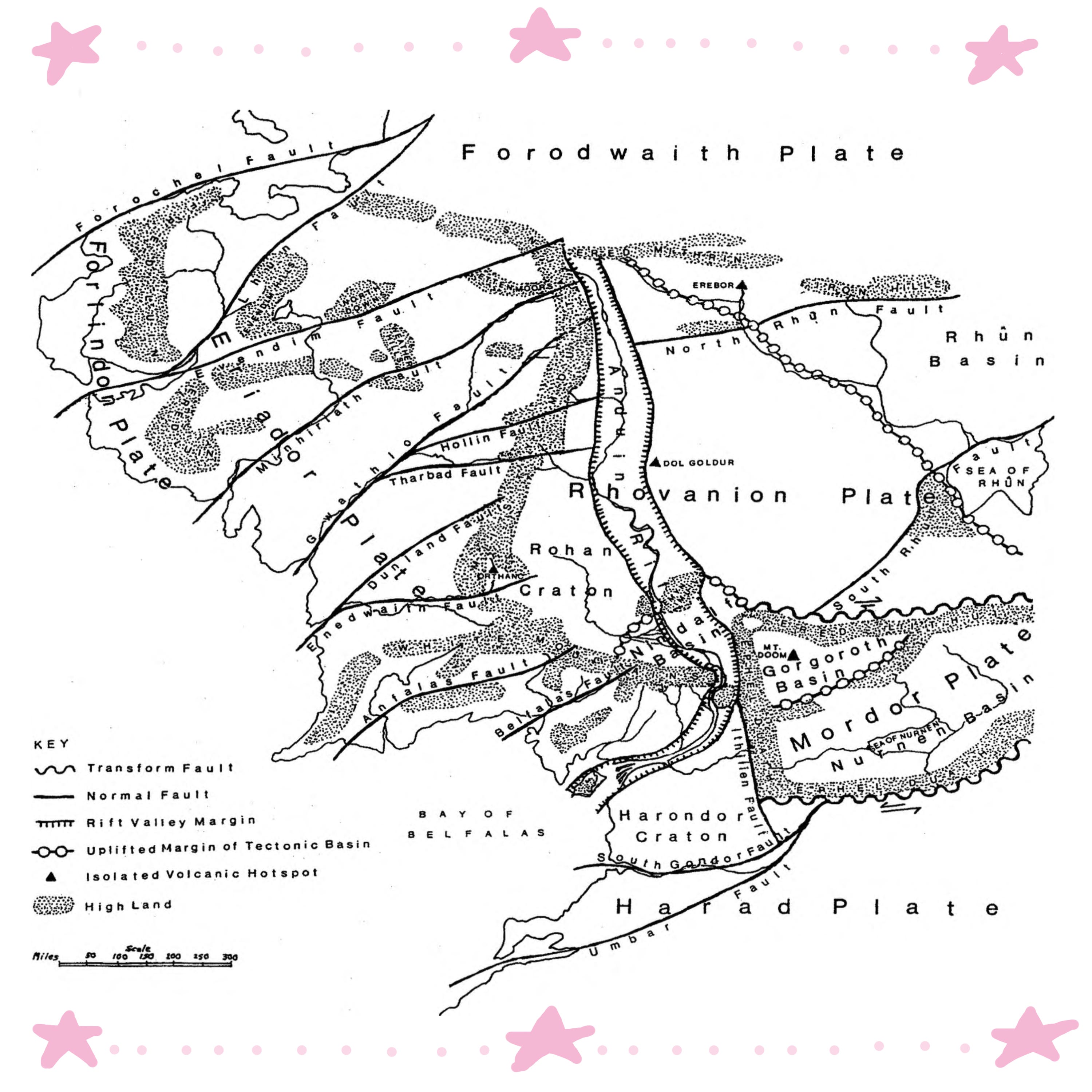
In Sarjeant’s map, the plate boundaries haven’t been marked but you can assume they lie near the mountain ranges.
For example: the Misty Mountains marks the collision of the Eriador and Rhovanion Plates. And similar to the Andes, the Eredluin mountains were birthed when the Forlindon Plate was crumbled under the thicker continental Eriador Plate.
Mordor encroaches in on the Rhovanion and Harad plates, springing up mountains on all sides. A real-world comparison could be the Tarim Basin, in Asia. This is a flat desert which is surrounded by mountains on most sides: the Tien Shan to the North, the Kunlun to the South, and the Pamirs to the West.

Here’s a Google maps image from the Murghab area in Tajikistan, to the West of the Tarim Basin. Kinda Mordor-y, huh?

But tectonics don’t just create mountains, they can also cause valleys. So let’s move on to the Anduin River.
✊🏻✊🏻 Knock Knock! Who’s there? Anduin. Anduin who? An-duin my best, okay?? (you have to say this one out loud to get it)
🌊 Raftin’ On The Great Rifty River
You know the scene where Frodo And The Gang row down the river, passing those formidable statue dudes? Well, they were travelling down the Anduin, the Great River of Middle Earth.
We know from the description of the Anduin River that a large portion of it flows through a cliff-faced valley:
on both shores there were steep slopes buried in deep brakes of thorn and sloe . . . behind them stood crumbling cliffs, and chimneys of grey weathered stone dark with ivy; and beyond these again there rose high ridges crowned with wind-writhen firs.
Sarjeant reckons it’s a failed rift valley.
But Olivia I don’t even know what a un-failing rift valley is, I hear you say! A rift valley is created by a weakening in the Earth’s crust, and it starts to split apart. Famous rift valleys include the East African Rift.
The hypothesis is that, with the triple collision of Eriador, Rhovanion and Mordor, this forced stress upon the crust, creating a failed rift valley, which is where a rift begins but never really gets going.
A rift with a river that comes to mind is the one in Iceland, although this is one is muuuuuuuch younger, and active. Maybe this is what the Great River looked like in its infancy:

Another explanation for the Anduin river and its cliff-lined banks is that it formed like the Colorado River in the US. In this case, the crushing together of tectonic plates caused uplift of the area. As my geology teacher Nick Zentner always said,
˗ ˏ ˋ UPLIFT INCREASES EROSION ˎ ˊ ˗
which means that as the land rose, the erosional power of the Anduin River cut down, and sawed a deeper channel through the rocks. Zooooooom.
At one point on their journey down the river Frodo notices the landscape becomes steeper on each bank, with cliffs made of limestone and great mountains beyond. This made me think of the Verdon river in the South of France, which passes through rocky limestone hills and has carved a dramatic gorge for itself.
🌋 Evil Hot Spots
But enough about plate tectonics!! Let’s talk about the volcanoes. If you look at the map of Middle Earth you can see that some volcanoes sit far away from any plate boundary. But I thought volcanoes only lived at plate borders! What’s the deal with that?
✊🏻✊🏻 Knock Knock!!! For God’s sake, who’s there already? Hotspots! Hotspots who? Hotspots: locations where the underlying mantle is extra hot and volatile, generating volcanic activity. They explain volcanoes where there’s no nearby tectonic border. Boom! (I couldn’t think of a joke for this one)
Hawai’i is a hotspot, and so is Yellowstone, although they are two very different kinds of hotspot. Hawai’i has regular eruptions, and Yellowstone has been ominously silent for the last seventy-thousand years.
Middle Earth has some hot spots, too! Although, unlike Hawai’i and Yellowstone, they are EVIL HOTSPOTS. Because each lone-standing volcanic structure is shrouded in the powers of darkness, in some way or the other.
Of course, we are talking about Mount Doom, the most evil fictional volcano of all time (please, tell me if there is a more evil fictional volcano). Mount Doom must be a stratovolcano, since it is very tall and cone-shaped. This means it has been built from thick, silica-rich lava. This makes a volcano build upward more, as the lava runs slower and cools closer to the slopes of the mountain. Thicker lava also makes these kind of volcanoes especially explosive, like Mt. St. Helens.
Other evil hotspots include Dol Guldur in Mirkwood (a former Sauron mojo dojo casa house), the Lonely Mountain Erebor, and Orthanc, Saruman’s tower at Isengard.
Let’s zoom in to Isengard a little more.
It’s described as a circular basin, surrounded by a rim of rocks:
A great ring-wall of stone, like towering cliffs, stood out from the shelter of the mountain-side . . . a great circle, somewhat hollowed like a vast shallow bowl: a mile it measured from rim to rim.
Tolkien suggests that Orthanc, the tower of Isengard, was actually a “thing not made by the craft of Men, but riven from the bones of the earth in the ancient torment of the hills.”
Sarjeant argues that the ring of Isengard must have been a volcanic crater, and that Orthanc was a volcanic spine: a solidified column of lava that shot upward from the crater during its eruptive period.
A real-life example of this is the volcanic spine of Mont Peleé, in 1902.
But the thing about volcanic spines is that they can collapse. The Mont Peleé growth lasted less than a year before crumbling. Not a solid foundation for a tower!
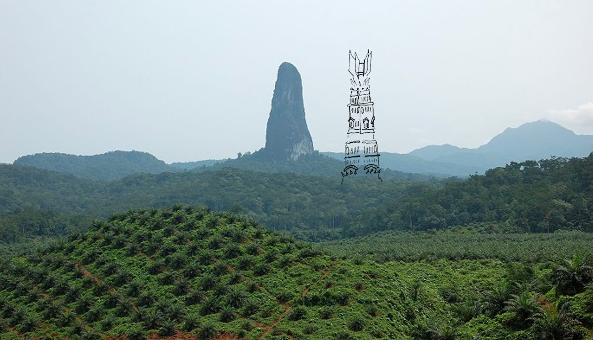
Another explanation for Orthanc that I prefer is by Karen Wynn Fonstad, who wrote a book called The Atlas of Middle Earth. Orthanc could have been a volcanic plug, which is magma that solidifies in the volcanic chamber, and is then is uncovered by erosion. In which case, maybe Orthanc originally looked a bit more like the Pico Cão Grande, which sits on an island off the West coast of Africa:
🐟 Back To Gollum
Thinking about all of this stuff, I wonder if would-be geologist Gollum (geologist… Gollum… gollumologist?) would be satisfied with these explanations. Nasty little tectonic plateses! They wants to make volcanoes!
Of course we can’t ignore the real geologist in the fellowship: Gimli. (please join my Gimli fan club because he is the best)
Now, I’ve barely scratched the surface of this! There’s much more to say about the geology of Middle Earth, from the chalky downs of the Shire to the Mines of Moria. If there’s anything you are absolutely bursting to add, as you read this, leave a comment!
Also, if you wanna read more about the geography of Middle Earth, please take a look at the books/articles I referenced for this post, down below.
I worked my little bottom off for this week’s edition of A Constellation, so if you know of someone who would dig this because they are a Lord of the Rings and/or geology nerd then send it to them!

📝 JOIN ME IN THE COMMENTS SECTION…
🪨 One for the geographers and geologists: do you have any theories on the geology of Middle Earth? Do you have any CORRECTIONS? Tell me your hot geological takes.
🧝🏻 One for the LOTR fans: you’re teaming up with a member of the fellowship to take down some orcs. Who’s your fighting partner?
🥾 One for everybody: what’s the longest walk you’ve ever been on? Did you love it or hate it? Tell me about it!
REFERENCES

✊🏻✊🏻 Knock Knock! WHAT!??!?! Don’t forget, you can support this project directly by taking a minute to do one of these things:
buying a ‘Gneiss Guy’ tote bag on my Bandcamp
listening to my music on Spotify and adding it to your playlists
forwarding this newsletter to a friend!
and if you haven’t already, subscribe:
Til next time! Be good,
Olivia 🌈✨🏔🎶

This was such a fun geological jaunt! Being an LotR fan is teaching me so much about maps and geographical features. Also I would 100% be teaming up with Gandalf, I hope he doesn’t call me a fool and lets me go for a ride on Shadowfax after the battle.
I enjoyed this, even though I’m not really a fan of Lord of the Rings or geology (A-level geography: ugh). But I am a fan of entertaining writing and people being really enthusiastic about random (to me) things and puns about the Andes (which, of course, you’ll find on the end of your armees).